Nepal is a country of geographical diversity, with three different regions: Terai, Himal, and Hilly. The land surface of Nepal is not uniform. There are many mountains, plateaus, hills, valleys, etc.
The highest point in the country is Mount Everest, at 8,848.86 meters and the lowest point is Mukhiyapatti Musharniya of Dhanusha District, at 59 meters. This remarkable contrast in altitude between these two points highlights Nepal’s diverse and dramatic topography.
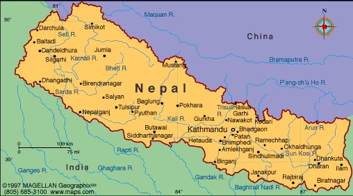
Nepal is a landlocked country, with China to the north and India surrounding it on all other sides. The total geographical area of Nepal is 147,516 square kilometers and occupies an area from 26 ° 20′ to 30° 10′ north latitude and 800 ° 15′ to 88 ° 19′ east longitude.
Nepal’s geography can be broadly categorized into three major regions:
Himalayan Region
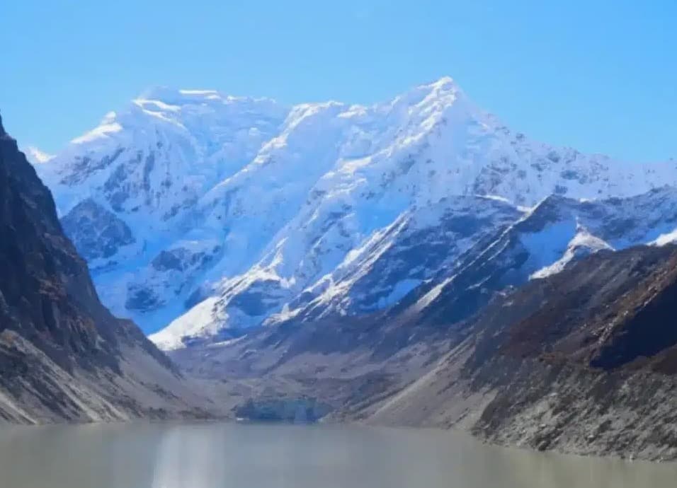
The magnificent Himalayan mountain range dominates the northern part of Nepal. In Nepal, the mountainous area is referred to as “Parbat”.
This mountain region encompasses a mere 16% of Nepal’s total land area and is sparsely populated, primarily due to its challenging weather conditions and less fertile soil. The Sherpa people are a distinctive ethnic group native to this Himalayan region.
Nepal is home to eight of the world’s 14 highest peaks that soar above 8,000 meters, including Mount Everest (8,848.86m), Kanchenjunga (8,586m), Lhotse (8,516m), Makalu (8,463m), Cho Oyu (8,201m), Dhaulagiri (8,167m), Manaslu (8,163m), and Annapurna (8,091m). These monumental mountains add to the grandeur and significance of Nepal’s Himalayan region.
Hilly Region
Hills are the central part of Nepal and play an important role in Nepal’s geography. Also known as “Pahar” by Nepalese, this part of Nepal features a captivating landscape of rolling hills and picturesque valleys. The hilly region covers a substantial 65% of Nepal’s total land area, making it the most urbanized area in the country.
As Nepal has a high degree of geographical diversity, the climate in the hilly regions is very different from the Himalayan region. The daytime temperatures are moderate, with warm summers and chilly winters providing a balanced seasonal contrast. During the monsoon or summer season, the area receives ample rainfall, contributing to its fertility.
Diverse ethnic communities, including Newari, Brahmin, Chhetri, Magar, Gurung, and Tamang, call this hilly region home, resulting in a vibrant cultural tapestry. This region serves as the geographical core of the nation, hosting numerous major cities and towns, including the vibrant capital, Kathmandu.
Terai Region
Geography-wise, Terai is the lowest region in Nepal and is located in the southern part of Nepal. It is a low-lying plain that runs along the border with India, covering 17% of the country’s land. This region boasts fertile agricultural land and is renowned for its lush forests and abundant wildlife. The Terai’s climate is hot, with summer temperatures often exceeding 45 degrees Celsius.
The Terai’s landscape consists of vast plains and dense forests, making it home to various wildlife reserves and subtropical woodlands. One of its most famous features is Chitwan National Park, a sanctuary for diverse flora and fauna.
Madhesi communities primarily inhabited the Terai, along with various indigenous groups from diverse ethnic backgrounds. These people play a significant role in the region’s agriculture and contribute to its cultural diversity. Terai plays a pivotal role in Nepal’s economy, particularly in agriculture, and is vital for the nation’s overall prosperity.