
Nepal is a beautiful country, and the white mountains are the icing on the cake. Last season, in April 2024, I trekked to Nepal’s most famous Everest Base Camp Trek from Kathmandu and climbed Lobuche East Peak. The experience was unparalleled. No doubt, it’s one of the best adventures in the heart of the Himalayas.
The breathtaking views, challenging terrain, picturesque Sherpa villages, local people, food (especially Dal Bhat), and accommodation were all so good. Everything about the experience was fantastic.
Over several days, I trekked through forests, crossed suspension bridges, visited monasteries, and saw amazing mountains and landscapes. Until now, this trek has been the best excursion for me.
If you are also a hiking enthusiast, it’s a must-do bucket list program. No wonder, on the same tour, you trek and also climb a 6,000-meter peak.
Let me help you get in there! Here’s the day-to-day detailed itinerary I followed. It’s also a write-up about my personal experience of the tour, so you can get a raw understanding of what the trek looks like.
Day-to-Day Itinerary for Everest Base Camp Trek with Lobuche East Peak Climb
Nepal is beautiful, and the white mountains are the icing on the cake.
Climbing Lobuche East via EBC is a well-built hiking route with cozy teahouses at every stopover. Before summiting one of Nepal’s renowned trekking peaks, I trekked to the foot of the highest mountain in the world. Reaching Everest Base Camp is a significant milestone, offering a close-up view of the highest peaks.
Arrival into Kathmandu
My adventure to Lobuche Peak began in London, where I boarded a flight to Kathmandu with a layover in Delhi. Despite delays and the inevitable jet lag, the warm welcome in Nepal quickly lifted my spirits. As I exited the bustling airport, Sanjib from Heaven Himalaya greeted me with a garland of marigold flowers, a traditional Nepalese welcome that immediately made me feel at home. Sanjib whisked me away to my hotel in Thamel, the vibrant tourist hub of Kathmandu, where I would stay for the next two nights. Thamel’s bustling streets, lined with colorful shops and restaurants, were a feast for the senses. After a quick trek briefing, I settled in for the night.
The next day, I ventured to Thamel, determined to gather a few missing bits of kit for my trek. I was amazed by the number of trekking shops, each packed with gear of all kinds, making my mission very easy.
In the afternoon, I met my guide, Shankar, a seasoned trekker with years of experience in the Himalayas. His stories of past treks, challenging climbs, and breathtaking views filled me with excitement and anticipation. We went over our route, discussed the acclimatization process, and shared tips on handling the high altitudes.
Surviving the Lukla Flight: ‘The Most Dangerous Airport in the World’!
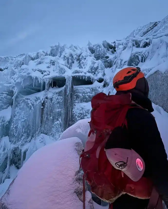
Often dubbed ‘the most dangerous airport in the world,’ Lukla Airport (also known as the Tenzing-Hillary Airport) is the gateway to the Himalayas and a rite of passage for every trekker. Lukla has one of the shortest and most challenging runways in the world, with 527 meters long and 30 meters wide and a hair-raising 11.7% gradient.
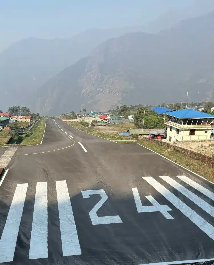
Leaving the hotel at 2 AM, we embarked on the bumpy ride to Ramechhap, hoping to catch the first flight of the day at 6 AM. If you’ve ever dealt with mountain weather, you know that time is more of an optimistic guess than a strict schedule. I had heard tales of trekkers stranded for days due to bad weather, but luck was on our side. Around 7:30 AM, with my heart lodged firmly in my throat, we took off and landed safely at the infamous Lukla Airport.
Trekking from Lukla to Monjo (13 km to 2,835 m)
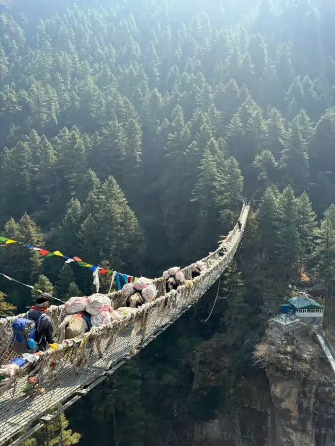
Our trek began with a gentle descent to Phakding, a small village nestled at 2,610 meters. The trail meandered through picturesque villages and lush forests, with the Dudh Koshi River rushing alongside. We crossed several suspension bridges adorned with fluttering prayer flags, each step bringing us deeper into the Khumbu region. The serene beauty of the landscape was both humbling and invigorating, a perfect introduction to the trek. The walking was gentle and took just a couple of hours. We grabbed an early lunch in Phakding and decided to push on a little to the quaint mountain village of Monjo (2,835 m). We settled in for the night at our first tea house.
Monjo to Namche Bazar (8 km to 3,440 m)
After hearing stories about how difficult it can be to get a good night’s sleep on the trek, I was pleasantly surprised by how well I slept. The temperatures remained relatively warm at this altitude, making it a cozy night’s sleep. Today’s goal was to reach Namche Bazaar. My alarm sounded at 6:30 am, and after a hearty breakfast, we hit the trail around 7:30 am.
The hike to Namche Bazaar typically involves the most elevation gain of any day on the trek. The terrain was a bit more challenging, with increased steps and uphill sections. However, the breathtaking views and scenery more than made up for the exertion. During the walk, we officially entered Sagarmatha National Park through the Jorsalle Entrance Gate. Along the trail, we passed the iconic dual bridges spanning the river below, known as the Hillary Bridge. We paused to let tourists and yaks cross before beginning the steep ascent up the ridge to Namche Bazaar.
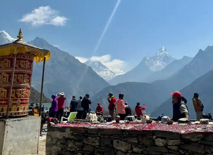
We arrived in Namche in the late morning. The extraordinary setting at 3,440 m above sea level is insane. The town boasts a vibrant array of amenities, including coffee shops, bars, mountain clothing stores, bakeries, schools, clinics, pharmacies—the list goes on. It is even home to the highest pub in the world! Everything in Namche arrives via porters, yaks, or helicopters, showcasing the town’s remote accessibility.
Many trekkers opt to stay an extra night in Namche for acclimatization, a crucial step in mitigating the risks of altitude sickness. This condition doesn’t discriminate; even the fittest and most seasoned trekkers can succumb to its effects. Spending an additional day in Namche allows your body to adjust gradually to the increasing altitude, reducing the likelihood of altitude-related issues. As I had trekked at altitude before, luckily, with no sickness, we decided we would just spend one night here before heading to Debouche.
Namche Bazar to Debouche (12 km to 3,820 m)
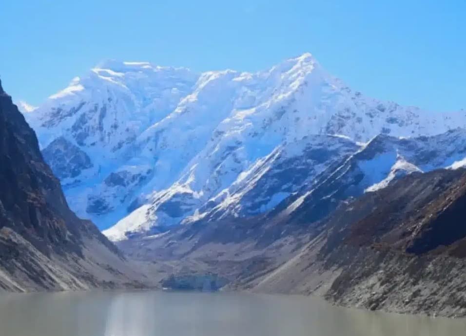
After breakfast, we set off on the dusty trail from Namche to Debouche. Along the way, we reached a viewpoint that offered a breathtaking panorama of Everest, Lhotse, and Ama Dablam for the first time. Seeing these majestic peaks together truly put the magnitude of our journey into perspective, igniting a newfound excitement. The day began with a gentle walk, meandering through the valley and passing by stupas and temples. As we gradually ascended, we adopted the mantra of “bistari, bistari”—Nepali f for “slowly, lowly”—a phrase often repeated to emphasize the importance of pacing oneself to avoid altitude sickness.
En route to Debouche, we journeyed through Tengboche, home to the renowned Tengboche Monastery, the largest in the Khumbu region. Intrigued, we ventured into the monastery, where we were honored to receive a blessing from a monk. This ritual symbolized a passage of safe mountaineering and trekking in Nepal. We then headed to Debouche, where we grabbed some well-deserved lunch and settled in for the night.
Debouche to Pangboche (2 km to 3,930 m)
Feeling the need to prioritize rest and acclimatization, I decided to take some time to rest. Despite the frustration of dealing with an injury, I knew it was essential to listen to my body. We enjoyed a leisurely morning at the tea house before embarking on a brief one-hour walk to Pangboche. The effort was rewarded after I stepped into my room. As soon as I entered, the breathtaking sight of Ama Dablam greeted me from my bedroom window.
Pangboche to Dingboche (6 km to 4,410 m)
Today, our trek took us from Pangboche to Dingboche, a gradual journey characterized by gentle inclines and descents. As we progressed, the snow-capped peaks emerged from behind the clouds, revealing stunning views of the majestic mountains. It was during this stretch that I caught my first glimpse of Lobuche Peak, and the challenge ahead truly sank in.
With the dropping temperatures, I found myself layering up, opting for a woolen base layer to keep warm during our trek.
Dingboche, much like Namche, is a bustling mountain town offering various amenities. I spent the afternoon at Cafe 4410, a coffee shop that felt almost, surprisingly, like a slice of London despite being situated at an altitude of 4,410 m above sea level! The cozy sofas, relaxed atmosphere, ample charging points, and delicious coffee made it the perfect spot to unwind and recharge before continuing our trek.
We spent an extra day in Dingboche for acclimatization, aiming to head up to Nangkartshang Peak (5,060 m) to follow the “climb high, sleep low” strategy. This approach helps the body adjust to the elevation. Enjoying a slightly more leisurely morning, we set off around 8:30 am, reaching the peak after a couple of hours of walking. The air felt noticeably thinner, but fortunately, I was symptom-free at this stage. The views from the top made every step worthwhile, with Island Peak and Ama Dablam towering majestically among the surrounding mountains. After capturing a few pictures, we began our descent, satisfied with the day’s accomplishment.
Dingboche to Lobuche (12 km to 4,940 m)
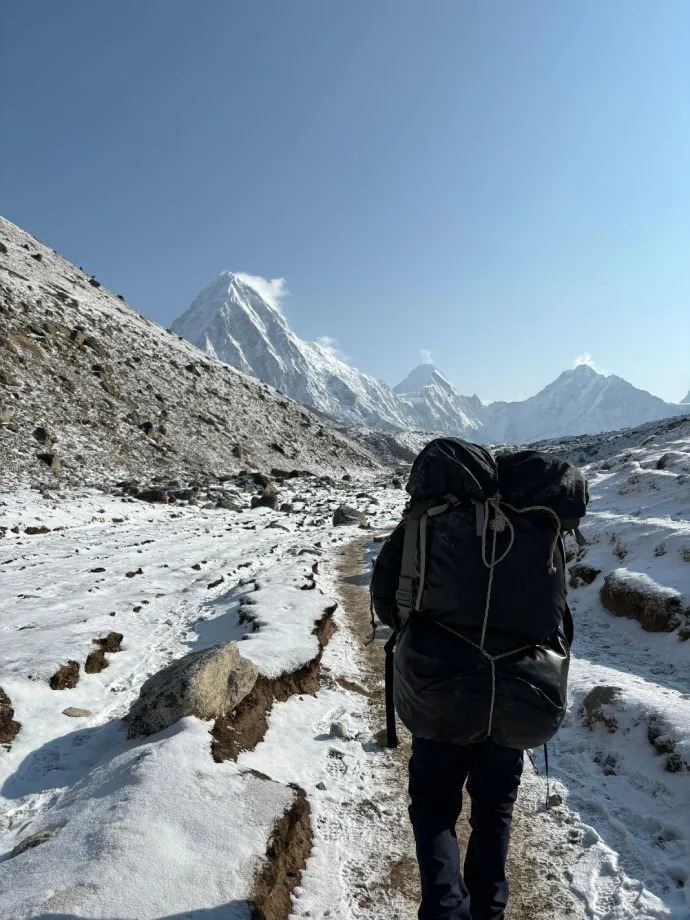
Today, we trekked from Dingboche to Lobuche. The hike was mostly gradual with a gentle elevation gain, except for one steep section known as the Thukla Pass, which we approached slowly and carefully. At the top of this section, we reached the Everest Memorial. I found this incredibly emotional. The memorials, each dedicated to a climber who lost their life on Mount Everest, served as a poignant reminder of the extreme risks taken by those striving to achieve their dreams.
From the memorial, the views were increasingly beautiful. We arrived in Lobuche late in the morning, feeling both humbled and inspired by today’s journey.
Lobuche to Gorak Shep (5,180 m) and Everest Base Camp (10 km, 5,364 m)
It was an exciting start to the morning, knowing we would finally trek to Everest Base Camp today. In terms of views, this was one of the most stunning days. After around two hours of trekking through a gradual rocky incline, taking more frequent breaks to catch our breath, we reached Gorak Shep. Here, I left my bags, as we would be spending the night, and had an early lunch before continuing our journey to Everest Base Camp.
Shortly after arriving in Gorak Shep, I began to feel a headache creeping across my eyes. Hoping it was due to a lack of water or tiredness rather than the altitude, we pressed on, although my headache worsened. Our pace slowed to a crawl, but I was determined not to let anything stop me from reaching Everest Base Camp today. As the Khumbu Glacier came into view, it momentarily distracted me from the pain. Having seen countless photos and films of this infamous glacier, it was surreal to witness it in person. We descended from the trail and finally arrived at the iconic Everest Base Camp rock.
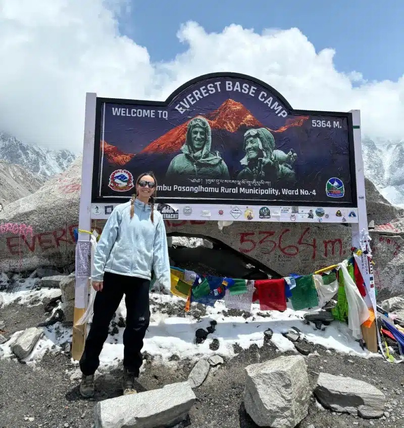
We took many photos and savored the moment of accomplishment. However, for me, the hard part had only just begun. My headache was worsening, so we quickly left and slowly made our way back to Gorak Shep. Recognizing the severity of my symptoms, I decided it was time to take Diamox, the altitude sickness medication. That evening, I went to bed feeling apprehensive, uncertain about how the night would unfold, and hoping the medication would help me through.
Gorak Shep to Lobuche (4 km to 4,940 m)
Thankfully, the Diamox worked well, and I woke up feeling refreshed and almost back to normal, ready to head back to Lobuche for the night. While many trekkers go on to climb Kala Patthar (5,644 m) at this point, I decided to skip it to conserve my energy after the previous night’s headache. Instead, I decided to return to Lobuche and take a rest day.
Lobuche to Lobuche High Camp (5,400 m)
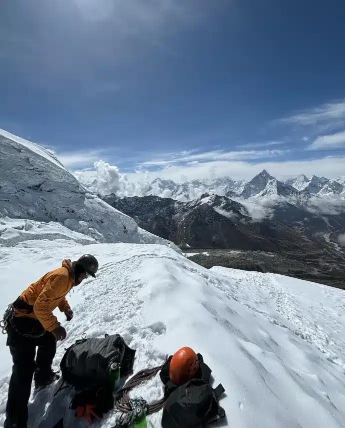
This morning marked the start of the challenge that brought me on this journey: to climb over 6,000 meters above sea level. We began with kit checks to ensure I had everything needed for the following night. I met my Sherpa, Namgel, for the first time, who would guide me up to Lobuche.
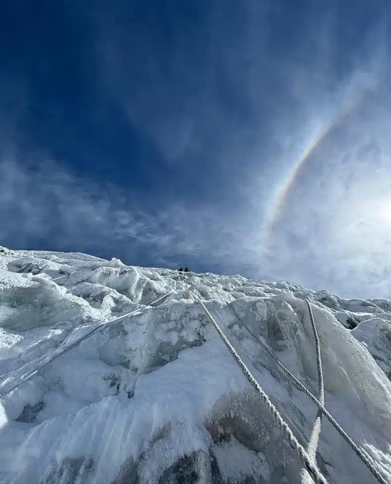
We set off around 9 am, embarking on a slow ascent to high camp. The climb was steep, with many precarious rocks, so we took it cautiously. Significant snowfall the night before made it trickier to find secure footing. After a couple of hours, we arrived at high camp and spent the rest of the morning doing rope training. We had dinner around 6 p.m. and then turned in early to rest before the summit push.
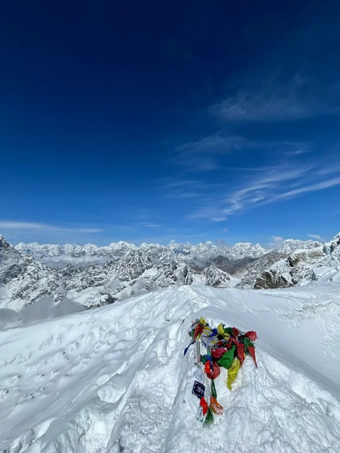
Lobuche High Camp to East Peak Summit (6,119 m)
Most people say that sleeping at a high camp is nearly impossible due to the altitude. To my surprise, I slept so soundly that I missed three of my alarms, only waking up when the fourth went off, leaving me momentarily confused. I managed to get around four hours of sleep and felt ready to go. We had ‘breakfast’ around 12:30 am and then headed off into the darkness to begin the summit push.
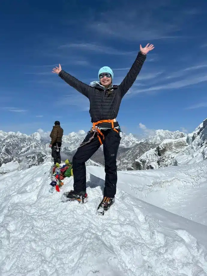
We walked on snow and rock for about 4.5 hours, taking frequent breaks, before reaching the crampon point. Here, we put on our helmets and crampons and began the steep climb, which turned out to be one of the toughest challenges, both mentally and physically, that I have ever faced. Despite feeling extremely weak, Namgel’s unfailing encouragement and expert guidance kept me pushing forward, proving invaluable during the challenging ascent. At 8:30 am, we reached the summit.
I was overwhelmed with relief and a sense of accomplishment. After taking some pictures, we began our descent. My hands, weakened by exhaustion, struggled with the carabiner and rappel, but Namgel’s unwavering support made the daunting task feasible. After about 5 hours, High Camp was in sight! Following a much-needed lunch break, my porter collected me, and we headed back to Lobuche village. What should have been around a 2-hour walk took over 3 hours. My feet were protesting each step. However, seeing Shankar with arms open wide, ready to greet me, was a moment I will never forget. I had done it!
The Descent: Lobuche to Upper Pangboche (11 km, 3,985 m) to Namche (20 km, 3,440 m) to Lukla (21 km, 2,860 m)
As it was time to descend, I felt a mix of emotions—a bittersweet feeling. With the route of descent varying, we opted to head towards Upper Pangboche. Unfortunately, so many other things occupied my mind on my Lobuche summit that I forgot to apply sun cream! The consequence? An iconic explorer burned, leaving my face bright red with just the mark of sunglasses. The sunstroke was quite severe. Realizing the need for recovery, we decided to take a rest day and stay at Pangboche until I felt better.
The following day, we embarked on the 20-kilometer journey to Namche. It proved to be a challenging day. ‘Descent’ on the Everest trail doesn’t always mean a straightforward downhill trek; there’s still a significant amount of incline to contend with. Despite not feeling my best, reaching Namche brought a sense of relief.
The subsequent day, we started early for our final trekking day. Descending to Phadking for lunch marked a milestone before our ultimate journey back to Lukla, where we spent our last night. Unfortunately, enjoying a beer wasn’t an option for me as I was still feeling unwell. However, the vibrant atmosphere in the tea house more than made up for it; the sense of accomplishment was immense.
Back to reality: the final flight back to Kathmandu
We woke early the next morning, eager to catch an early flight back to Kathmandu. After several hours of weather delays, we traveled back to Ramechhap and took a bus to Kathmandu. Saying goodbye to Shankar for the last time, I was filled with mixed emotions. I felt thrilled and proud of my climbing accomplishment, but also sad that the journey had ended. One thing was certain: this wouldn’t be my last visit to Nepal. Until next time…
In the end
The above Everest Base Camp and Lobuche East Peak Climb experience is a first-hand observation. It’s raw. I have lived every moment in here. Thus, you can write to us if you feel like adding days to the itinerary or customizing it.